Get ready for summer! A largely hot and dry forecast will be in the cards this week as an anomalous ridge of high pressure develops to our south pumping in air from the Deserts. There will be a few chances for isolated storms, with the best chance coming towards week’s end as a frontal system tries to make its way into the area from the north. Read on for details as the first “heatwave” of 2023 unfolds across the Front Range.
This week’s highlights include:
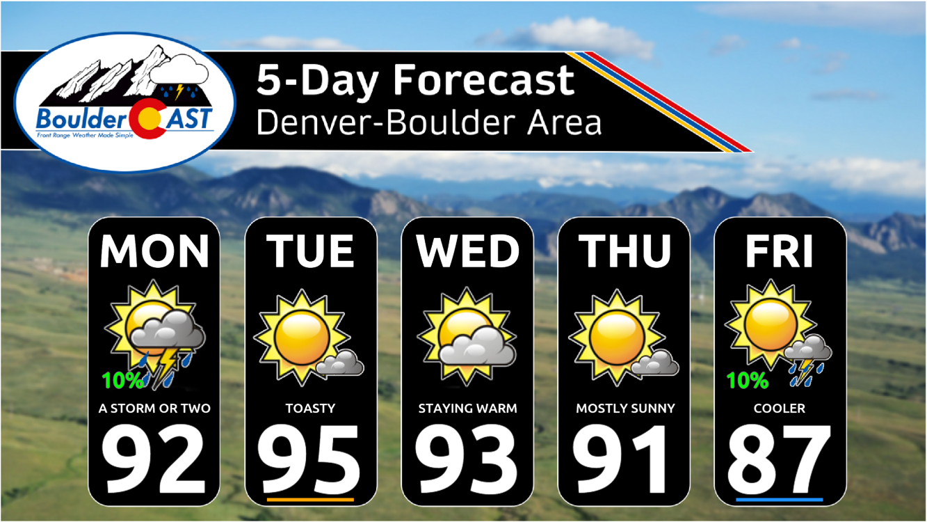
- Hot & dry most of the week with low to middle 90s as summer’s heat ramps up
- A cooldown into the 80s in the works for Friday and the upcoming weekend with a frontal system moving in
- Chances of rain are largely non-existent, but we may see a few small doses Monday and Friday
DISCLAIMER: This weekly outlook forecast is created Monday morning and covers the entire upcoming week. Accuracy will decrease as the week progresses as this post is NOT updated. To receive daily updated forecasts from our team, among many other perks, subscribe to BoulderCAST Premium.

Go Premium, get all the perks.
Daily Forecast Updates
Get our daily forecast discussion every morning delivered to your inbox.
All Our Model Data
Access to all our Colorado-centric high-resolution weather model graphics. Seriously — every one!
Ski & Hiking Forecasts
6-day forecasts for all the Colorado ski resorts, plus more than 120 hiking trails, including every 14er.
Smoke Forecasts
Wildfire smoke concentration predictions up to 72 hours into the future.
Exclusive Content
Weekend outlooks every Thursday, bonus storm updates, historical data and much more!
No Advertisements
Enjoy ad-free viewing on the entire site.
Join Premium Now
Hot & dry to start the week with limited rain chances
This has definitely been a uniquely cool/wet spring and early summer thus far. Boulder has seen back-to-back months with 5 inches of rainfall and has recorded just two measly 90-degree days thus far. Both of these trends will reverse this week as our first real taste of summer dry heat arrives…

The week starts off hot with a slight chance (10%) of a few afternoon storms. Most of our Monday will be dry, but there will be a weak mid-level shortwave traversing eastward from Utah during the day into the overnight. That should lead to some development of clouds and perhaps a few rumbles of thunder. The downside is the atmosphere has little moisture to work with, so we will largely stay dry. It will be hot with middle 90s over the Denver Metro area to begin to the week

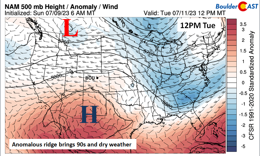
Most of our week will be driven by an anomalous ridge of high pressure to our south in Arizona and New Mexico. Westerly flow at the mid-levels over Colorado will keep us dry — monsoonal flow is usually from the southwest. It will also keep us hot in the low to middle 90s for the next handful of days. The forecast map below is for Tuesday.
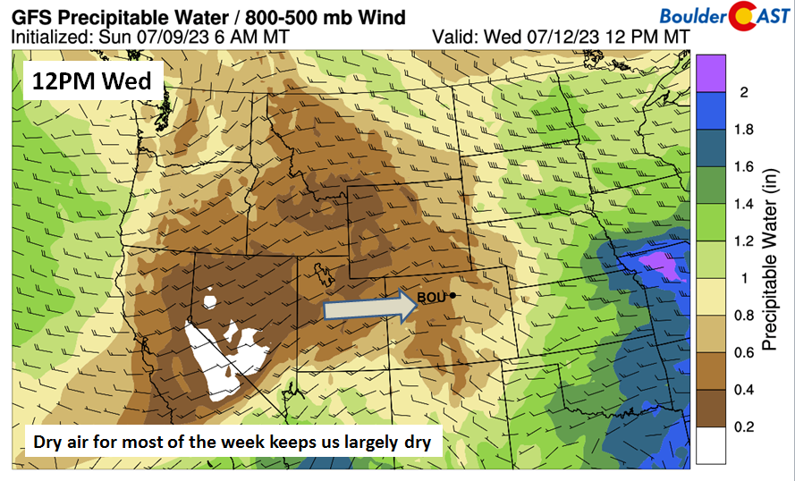
Very little shifts in the flow for Wednesday, with westerly flow still present as the ridge stays to our south.
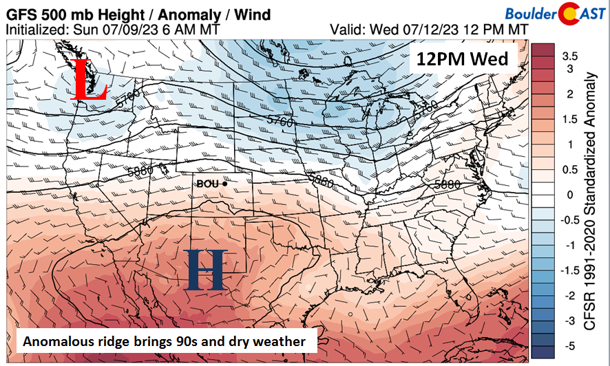
As a result, temperatures at the 700mb level (~10,000 feet up) reach 18°C on Wednesday, well supportive of the low to middle 90s.

The westerly flow will result in precipitable water values less than or equal to 0.5 inches — quite dry for this time of year — shutting down hopes for any potential storm development.
Turning cooler with a better chance of storms late in the week?
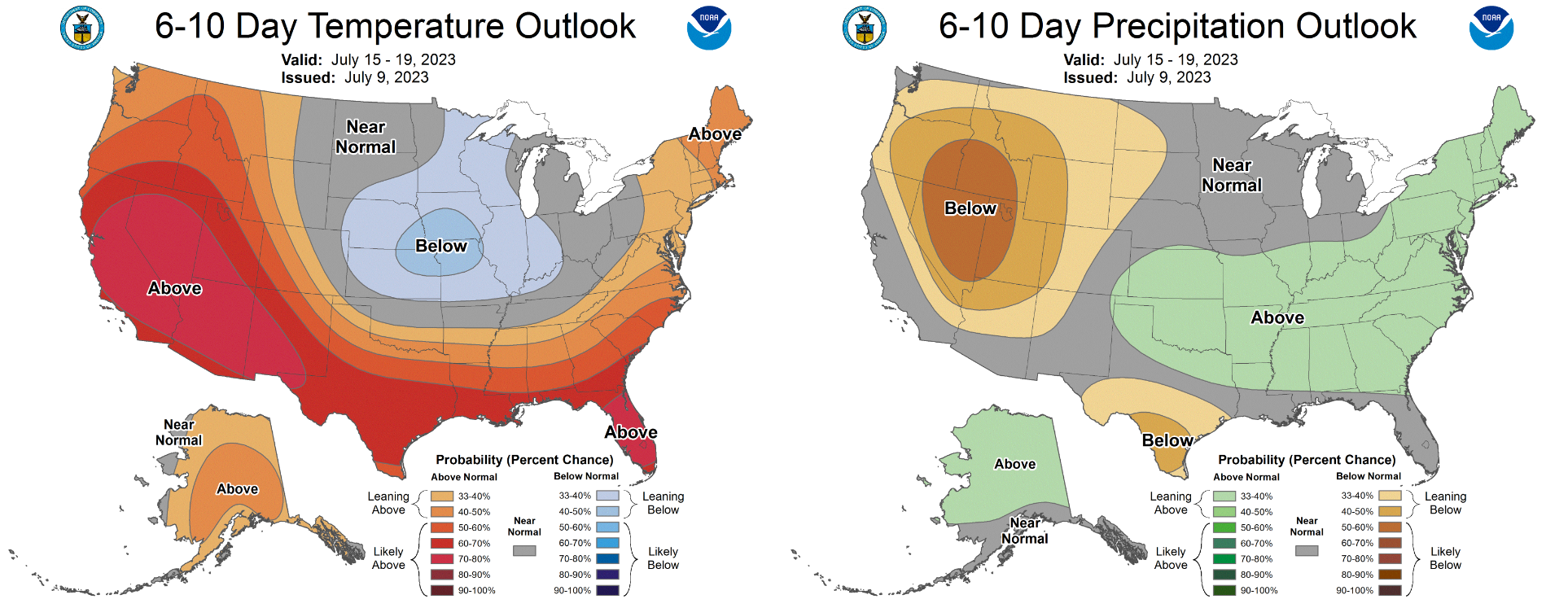
As we head into the latter part of the week, models are hinting that a large trough of low pressure will dive down into central Canada and the upper Mississippi Valley. This would allow a northwest flow to develop over Colorado, shunting the ridge over southern California. The result would be somewhat cooler temperatures in the 80s.

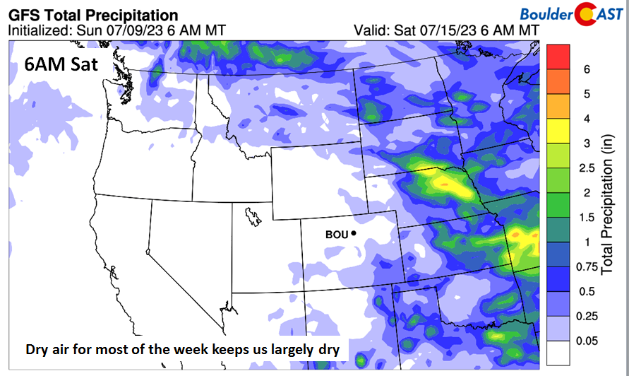
In addition, a frontal system is forecast to possibly move through Friday (below), which could also increase chances for isolated to widely scattered storms both ahead and behind the front.

All in all, though, it will be a fairly dry week. The plot below shows the expected total precipitation from the GFS through early Saturday. As you can see, most of our state is forecast to be nearly rain-free. We think the best chances of storms will bookend this hot week with~10% chances both Monday and Friday,
With the cold front digging in across the center of the country and the ridge getting shunted west, our area will end up between the two for the upcoming weekend into early next week with northwest flow over the area. Temperatures will likely be near seasonal normals for the upcoming weekend in the 80s with slight chances for late-day storms. Some storms could be severe but that should mainly be out near Nebraska and Kansas where moisture will be more prevalent.
Enjoy the first taste of summer heat this week — deep down we all knew it couldn’t stay cool forever!
Forecast Specifics:
Monday: Morning sun, then partly cloudy with a 10% chance of an isolated weak storm or two. Highs in the lower 90s on the Plains and near 80° in the Foothills.
Tuesday: Mostly sunny and hot with middle 90s on the Plains and lower 80s in the Foothills.
Wednesday: Partly sunny, breezy, and hot with lower to middle 90s for the Plains and lower 80s in the Foothills.
Thursday: Mostly sunny and warm with lower 90s for the Plains and lower 80s in the Foothills.
Friday: Plenty of sun early, but Increasing clouds with a 10% chance of late-day storms. Highs in the middle 80s on the Plains and middle 70s in the Foothills.
DISCLAIMER: This weekly outlook forecast is created Monday morning and covers the entire upcoming week. Accuracy will decrease as the week progresses as this post is NOT updated. To receive daily updated forecasts from our team, among many other perks, subscribe to BoulderCAST Premium.
Go Premium, get all the perks.
Daily Forecast Updates
Get our daily forecast discussion every morning delivered to your inbox.
All Our Model Data
Access to all our Colorado-centric high-resolution weather model graphics. Seriously — every one!
Ski & Hiking Forecasts
6-day forecasts for all the Colorado ski resorts, plus more than 120 hiking trails, including every 14er.
Smoke Forecasts
Wildfire smoke concentration predictions up to 72 hours into the future.
Exclusive Content
Weekend outlooks every Thursday, bonus storm updates, historical data and much more!
No Advertisements
Enjoy ad-free viewing on the entire site.
Join Premium Now
Get BoulderCAST updates delivered to your inbox:
Enjoy our content? Give it a share!